


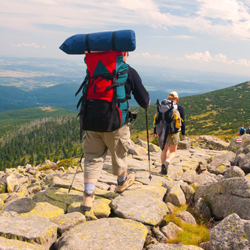
THE TIPPERARY 10 WALKS
The Tipperary 10 are a series of ten walks in South Tipperary.
Along river paths, mountain ranges and forest tracks you will discover bogs, butterflies and castles, and even walk in the footsteps of Ireland’s historic figures of St. Patrick and King Henry II.
Here are just two of the Tipperary 10 walks below.
THE EASTER MUNSTER WAY
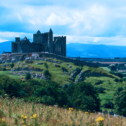
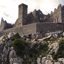
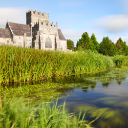
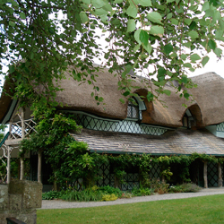
Ireland’s only Tudor manor, Ormond Castle, is the starting point to follow the towpath along the River Suir from Carrick-on-Suir. This walk starts in the town of Carrick-on-Suir, at the south east extremity of County Tipperary, and follows the River Suir upstream.
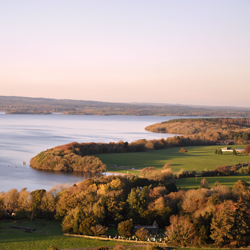
The Suir, held by some to be the second-longest river in Ireland, is majestic and slow-moving at this point, overlooked by old castles and churches, and home to otters and herons.
At the pretty village of Kilsheelan, the route crosses into County Waterford and ascends into the foothills of the Comeragh Mountains. It soon descends again to follow the Suir into the vibrant county town of Clonmel, which has a lot to offer those who linger. Leaving Clonmel the Way crosses a western outlier of the Comeraghs to reach the northern flanks of the Knockmealdown Mountains where it meanders westwards with spectacular views before descending to reach the town of Clogheen.
Terrain consists mainly of forestry tracks, riverside tow paths and quiet tarmac roads: some off-road paths may be a little overgrown. Total aggregate ascent over the route is less than 1700m, but there are some short, steep climbs.
Section 1 - Carrick on Suir to Kilsheelan
Section 2 - Kilsheelan to Clonmel
Section 3 - Clonmel to fourmilewater
Section 4 - Fourmilewater to Goatenbridge
Section 5 - Goatenbridge to Clogheen.
DESCRIPTIONS
Distance - 75km/43 miles
Estimated Time - 3 Days
Parking At Start - on street in Carrick-on-Suir and limited near start/end of Way At End - on street in Carrick-on-Suir and limited near start/end of Way
Start and Finish
Starting point is at Carrick-on-Suir. finishing point Clogheen
Minimum Gear - Hiking boots, raingear, fluid, snack and mobile phone
Grade - Moderate
BALLINACOURTY LOOP
This loop is one of a series developed at two trailheads in the glen (Christ the King Statue and Lisvarrinane).
A-B. From the mapboard in the green area at Christ the King statue follow downhill to enter the Nature Park. This loop is marked with purple arrows – but overlaps with two other loops (green and light blue arrows) and the long-distance Ballyhoura Way which is marked with the familiar yellow walking man and arrows. Descend wooden steps and over a footbridge and shortly afterwards you reach a Y-junction. Veer left here and follow the woodland trail for approximately 1km to reach a wooden stile. Exiting the stile the green loop turns right – you turn left.
B-C. You are now on a more substantial forestry track. Descend for 300m to reach a four-track junction where you turn right and follow a forestry track for 800m to exit at a surfaced road just uphill from the Aherlow House Hotel. Here you leave the light blue loop and turn downhill following the yellow Ballyhoura Way.
C-D. Pass the hotel and follow the tarred surface downhill to reach a sharp left bend where you turn right and enter forestry again.
D-E. Continue to follow the Ballyhoura Way along forestry tracks for a flat section before turning right and ascending through Ballynacourty Woods. After 1.5km you reach a T-junction where the Ballyhoura Way turns left and you overlap with other loops that start and finish in the village of Lisvarrinane.
You turn right here to begin the homeward journey.
E-F. For over 2km the loop traverses the southern shoulder of Slievenamuck Mountain and rejoins the light blue loop above the Aherlow House Hotel before joining a tarred roadway. Here you veer left.
F-A. Follow the tarred roadway for a short distance before turning right into forestry again. Following woodland trails, you pick up the green loop at a small stile, and after 1km reach a 3-way junction where you rejoin the outward route. Veer left and retrace your steps for 300m to regain the trailhead.
DESCRIPTIONS
Ascent - 240m
Distance - 10km
Estimated Time - 2hrs 30mins - 3hrs
Grade - Moderate
Minimum Gear - Walking boots, raingear, snack and fluid
Services - Lisvarrinane (5km) Tipperary (6km)
Terrain - Forestry tracks and woodlands trails